刘彦随1,2刘亚群1,2欧聪1,2
1.中国科学院地理科学与资源研究所2.中国科学院区域可持续发展分析与模拟重点实验室
Yansui Liu a b, Cong Ou a, Yurui Li a b, Liqiang Zhang c, Jianhua He d
a Institute of Geographic Sciences and Natural Resources Research, Chinese Academy of Sciences, Beijing 100101, China
b College of Resources and Environment, University of Chinese Academy of Sciences, Beijing 100190, China
c State Key Laboratory of Remote Sensing Science, Faculty of Geographical Science, Beijing Normal University, Beijing 100875, China
d School of Resource & Environment Science, Wuhan University, Wuhan 430079, China
Abstract:
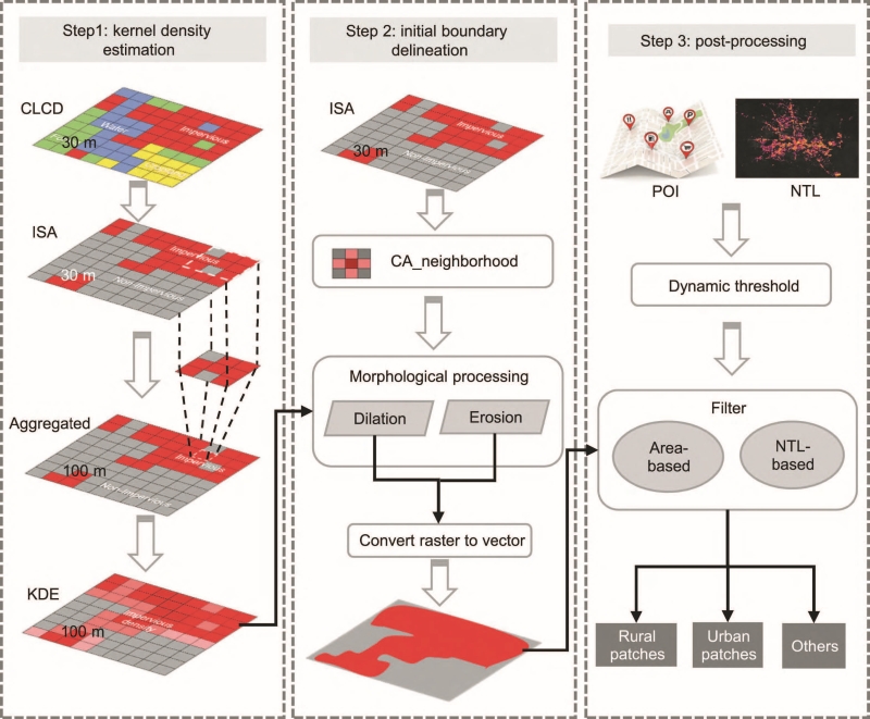
The systematic decline of rural areas in the process of rapid urbanization has become a global trend, creating greater challenges for sustainable rural development. As the spatial projection of socio-economic development and living environment in rural areas, the continuous tracking of rural settlements (RUS) is crucial to quantify the imbalance of rural development. However, consistent information on RUS is highly needed but is quite deficient in current research. In this study, a cost-effective mapping model was proposed to produce an annual RUS dataset in the rapid urbanization region of Beijing-Tianjin-Hebei (BTH) in North China during 1990–2020, and the temporal-spatial regularity of RUS changes was further analyzed. The location-based and the area-based comparison verified the effectiveness of our model, with a mean overall accuracy of 85% and a mean correlation value of 0.88, respectively. The total area of RUS in the BTH region increased by 2561 km2 from 1990 to 2020, while the average size of RUS remained stable after 2005. The annual change trends in RUS appeared with increasing and decreasing accounting for 76.33% and 23.67%, respectively. The centroids of RUS in Tianjin and Hebei have moved closer to Beijing, while those in Beijing have moved away from the former. Notably, we have identified 56.3% counties in the BTH region belong to the “Convex-I” change type in RUS. In general, our work can help to consistently quantify the spatiotemporal patterns of RUS in a cost-effective way, providing more explicit spatial information and continuous temporal information for rural residential land management.
Keywords:
Rural settlement changes; Rapid urbanization; Cost-effective approach; Rural areal system; Beijing-Tianjin-Hebei region
黄韬1刘素红2
1.陕西师范大学地理科学与旅游学院2.北京师范大学地理科学学部
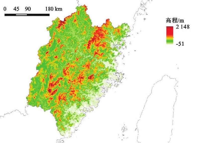
摘要:[目的]福建省森林覆盖率高达66.8%,是我国森林覆盖率排名第1的省份。探讨福建省土地利用变化对碳储量时空变化的影响是探寻社会发展和生态保护平衡点的理论基础。[方法]基于PLUS模型和InVEST模型碳储量模块,揭示2000-2020年全省碳储量时空变化特征与土地利用类型之间的关系,并从自然发展、生态保护和城镇发展3种情景预测2020-2030年福建省碳储量时空变化。[结果]2000年、2010年和2020年研究区的总碳储量分别为214.77×107,214.51×107,212.93×107t,呈逐年下降趋势。人类活动对土地的开发和改造是导致碳储量变化的主导因素,大面积的耕地和林地转变为建设用地是导致碳储量降低的直接原因。预测结果认为,与2020年相比,2030年自然发展、生态保护和城镇发展情景下碳储量分别减少1.47×10⁷t,增加0.17×10⁷t,减少1.85×10⁷t。生态保护情景是唯一逆转碳储量下降的发展情景,该情景与2020年相比,林地面积扩张1900.87km2,林地碳储量增长2.08×10⁷t,在切实保护生态的同时也能够满足城镇发展的土地需求。[结论]落实以林地保护为主,控制建设用地是福建省实现“双碳”目标的重要前提。
关键词:碳储量;PLUS模型;InVEST模型;碳达峰;福建省
璩路路1李裕瑞2,3王介勇2,3
1.重庆大学公共管理学院,重庆400044;
2.中国科学院地理科学与资源研究所中国科学院区域可持续发展分析与模拟重点实验室,北京100101;
3.中国科学院大学资源与环境学院,北京100049
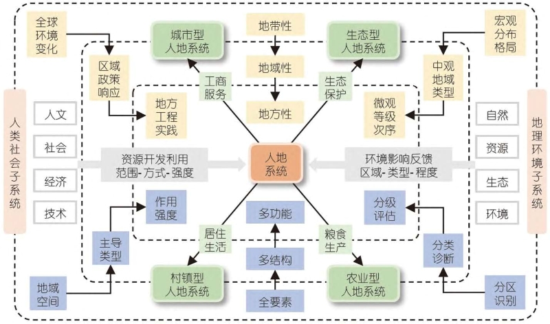
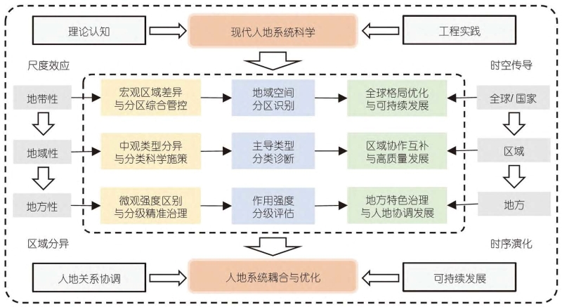
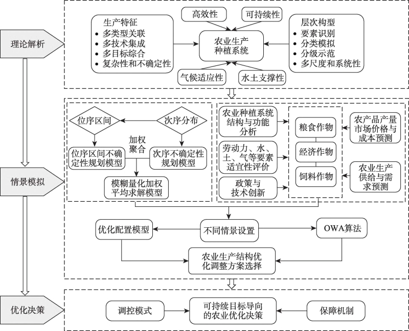
摘要:黄土丘陵沟壑区沟道农业是现代人地关系耦合发展的一种地域新类型,深入研究其生产特征及优化途径对于促进区域农业提质增效、推进乡村振兴和黄河流域高质量发展具有重要现实意义。以延安宝塔区作为典型案例,通过建立模糊量化有序加权平均的结构优化模型,模拟分析黄土高原沟道农业生产结构转型特征,研究提出沟道农业优化调控地域模式。研究表明:① 设置了维持现状型、经济优先型、可持续导向型和一季改两季型等四种沟道农业生产情景,不同地域类型及其不同发展导向决定着农地利用的多宜性和经营方式的多样性。② 不同类型区沟道农业发展演进成因及其机制存在明显差异,不同情景下沟道农业结构演变的特征与优化模式各异,农业规划、政策与技术因素对沟域尺度的沟道农业生产发展分异影响显著。③ 沟道农业的组织机制和技术创新,亟需着力解决三重关系、推进四种转变、实现四个优化,促进农业生产由广种薄收转向集约高效,农村经济由单一农业转向三产融合,进而实现沟道边坡植被改善、坝地种植结构优化、农业规模经营提高和乡城一体互动发展。
关键词:沟道农业生产;情景模拟;气候变化;优化模式;人地系统科学;黄土丘陵沟壑区
深圳大学建筑与城市规划学院,中国城市规划学会
Peng Cheng , Yongqin Fan , Houtian Tang , Ke Liu , Shiman Wu , Gaoli Zhu , Ping Jiang , Weili Guo
a School of Management, Wuhan Institute of Technology, Wuhan, 430205, Hubei Province, China
b School of Public Affairs, Xiamen University, Xiamen, 361005, Fujian Province, China
c School of Public Administration, Huazhong Agricultural University, Wuhan, 430070, Hubei Province, China
d School of Public Administration, Nanjing University of Finance & Economics, Nanjing, 210023, Jiangsu Province, China
e School of Resource and Environmental Sciences, Wuhan University, Wuhan, 430079, Hubei Province, China
f Guangxi Institute of Natural Resources Survey and Monitoring, Nanning, 530219, Guangxi Zhuang Autonomous Region, China
Abstract:
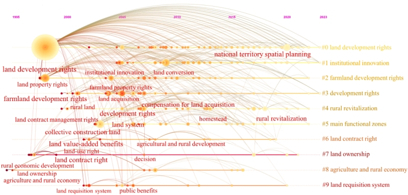
Based on the China National Knowledge Infrastructure (CNKI) and Web of Science (WOS) databases, this article analyzes the deductive context, cooperation network, and research hotspots of land development rights (LDR) research in the Chinese and international literature by using CiteSpace software, and it also explores the implications of this research for the theory and practice of national territory spatial planning (NTSP) in China. The results show that (1) the literature on LDR in Chinese and international journal articles initially appeared in 1995 and 1973, respectively, researches in China experienced three stages: embryonic fluctuating development, rapid growth and stable development, and wave development, while international researches experienced two stages: embryonic fluctuating and a gradually increasing development. (2) Among these scholars and research institutions, there is no obvious difference between Chinese and international scholars, while the Renmin University of China and the State University System of Florida are the research institutions with the largest number of Chinese and international journal articles, respectively. (3) In terms of publishing journals, international journals mainly focus on land policy, cities, and resource fields, while Chinese journals mainly focus on the agricultural economy, civil and commercial law, economic systems, and macroeconomic management fields. (4) The direction and scale of thematic research vary greatly, with Chinese research mainly conducted from the perspectives of rights attribution and benefits distribution, while international research mainly focuses on the operation of the right-to-development system and its impact on the environment. In the future, studies focus on China's need to strengthen the research and institutional practice of LDR at the legal level, value level, and extension level following national conditions, formulate a land value-added benefit distribution system with efficiency and fairness, and strengthen the practice of LDR in China's NTSP based on the differences between urban and rural development.
Keywords:
Land development rights; China's national territory spatial planning; Land value-added benefits; Hotspot research; Visual analysis; CiteSpace
Jieyong Wang , Haonan Zhang , Yaqun Liu , Yingwen Zhang , Haitao Wang
a Institute of Geographic Sciences and Natural Resources Research, Chinese Academy of Sciences, Beijing 100101, China
b College of Resources and Environment, University of Chinese Academy of Sciences, Beijing 100049, China
c Capital City Environmental Construction Research Base, Beijing City University, Beijing 100083, China
d Virginia Polytechnic Institute and State University, Blacksburg, VA 24061, USA
Abstract:
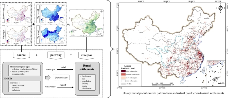
Impacted by large-scale and rapid rural industrialization in the past few decades, China's rural settlements are confronted with the risk of heavy metal pollution stemming from industrial production, which might pose a significant threat to the rural habitat and the well-beings. This study devised a relative risk model for industrial heavy metal pollution to the rural settlements based on the source-pathway-receptor risk theory. Using this model, we assessed the risk magnitudes of heavy metal pollution from industrial production at a 10 km × 10 km grid scale and identified the characteristics of the risk pattern in China. Our finding reveals: (1) the relative risk values of wastewater, waste gas and total heavy metal pollution are notably concentrated within a confined spectrum, with only a small number of units are characterized by high-risk level; (2) Approximately 21.57 % of China's rural settlements contend with heavy metal pollution, with 4.17 %, 9.84 % and 7.55 % being subjected to high, medium and low risks, respectively; (3) The high-risk units mainly is concentrated in the developed areas such as Yangtze River Delta, Pearl River Delta, and the Beijing-Tianjin metropolitan area, also dispersed in the plain areas with high rural population density. Guided by these insights, this study puts forth regionally tailored prevention and control strategies, as well as distinct process prevention and control strategies.
Keywords:
Heavy metal pollution; Rural settlements; Risk pattern; China
Linna Li, Jiayuan Cai, Wenfeng Chen
Faculty of Geographical Science, Beijing Normal University, Beijing 100875, PR China
Abstract:
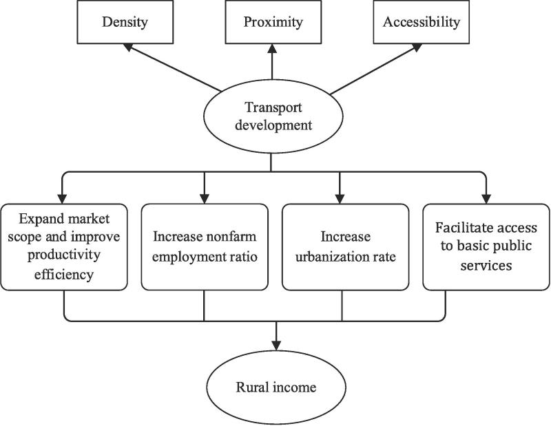
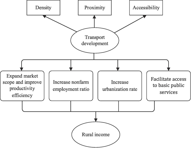
Transport development has often been regarded as a solution for increasing rural income. However, most existing studies focusing on the promotion effects of transport development on rural income fail to provide quantitative analysis of its influencing pathways. This study investigates the pathways linking county-level transport development to rural income in China. We first examined the spatial pattern of transport development, including density, proximity, and accessibility, in all Chinese counties from 2014 to 2019. Then, we analyzed both the association and influencing pathways between transport development and rural income using structural equation modeling (SEM). Finally, we compared the various effects and pathways among counties with different terrains, geographical locations, and poverty conditions through multigroup SEM analysis. The results suggest that transport development is associated with an increase in rural residents’ income primarily through the pathways of increasing nonfarm employment ratios, improving agricultural labor productivity efficiency, boosting urbanization rates, and enhancing access to basic public services. The most significant pathways through which transport development contributes to rural income growth in China are changes in nonfarm employment ratios and urbanization rates. The impact of transport development on rural incomes is more pronounced for counties in plain areas than counties in hilly and mountainous areas, more substantial in eastern counties than in central and western counties, and more pronounced in non-poverty-stricken counties than poverty-stricken ones. It is argued that transport alone cannot lead to significant rural revitalization in rural China; it must be accompanied by industrial development strategies.
Keywords:
Transport development; Nonfarm employment; Rural income; China; Structural equation modeling (SEM)
Link: https://doi.org/10.1016/j.tbs.2023.100708
Na Zhao , Kainan Chen , Xiaoran Wu , Lili Zhang , Wei Wang
a State Key Laboratory of Resources and Environmental Information System, Institute of Geographic Sciences and Natural Resources Research, Chinese Academy of Sciences, Beijing 100101, China
b College of Resources and Environment, University of Chinese Academy of Sciences, Beijing 100049, China
c Jiangsu Center for Collaborative Innovation in Geographic Information Resource Development and Application, Nanjing 210023, China
d First Institute of Oceanography, Ministry of Natural Resources, People's Republic of China, Qingdao 266061, China
e Aerospace Information Research Institute, Chinese Academy of Sciences, Beijing 100094, China
Abstract:
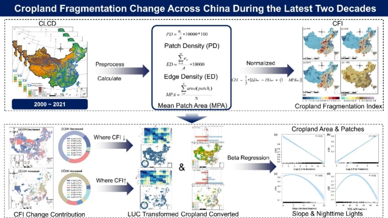
CONTEXT: There is an urgent need for a comprehensive assessment of cropland fragmentation that can provide valuable insights for guiding policies related to cropland protection, restoration, and other relevant measures. Despite the growing number of studies focusing on cropland fragmentation, a nationwide, long-term, and fine-scale understanding of the spatiotemporal changes in cropland fragmentation across China remains lacking.
OBJECTIVE: This study aimed to construct a novel comprehensive index that quantitatively assesses the level of farmland fragmentation, to fully elucidate the spatial and temporal dynamics of farmland fragmentation in China at the county level over the last two decades, and to identify the relationships between farmland fragmentation and key factors from anthropogenic and natural perspectives.
METHODS: Utilizing the 30 m annual and continuous time series Landsat-derived annual China land cover dataset (CLCD) from 2000 to 2021, we integrated three landscape pattern metrics- patch density (PD), mean patch area (MPA), and edge density (ED)- to devise a new comprehensive cropland fragmentation index (CFI). We also developed a Beta regression method to identify the relationships between CFI and key factors from human and natural perspectives.
RESULTS AND CONCLUSIONS: The results show that counties with high cropland fragmentation (CFI > 0.8) are predominantly located in the central part of China and the coastal areas, and the counties with low cropland fragmentation (CFI < 0.2) are mainly in the North China Plain, the Northeast Plain, and some areas in the northwest. Among counties experiencing an increase or decrease in fragmentation, the primary types of cropland conversions are between cropland and grassland, as well as between cropland and forests. A third major type of conversion involves the transformation of cropland into impervious surfaces. CFI had a significantly negative linear relationship with total area of cropland in each county while showing a positive relationship with the total cropland patches in each county. The variables CFI and slope, and CFI and nighttime light (NTL) data, exhibited a quadratic parabolic relationship.
SIGNIFICANCE: The findings presented in this study provide crucial insights into the underlying causes and patterns of farmland fragmentation in China. These insights will serve as a valuable resource for policymakers and land managers, enabling them to devise effective strategies for sustainable land use planning and promoting rural development in the country.
Keywords
